Detailed Engineering Planning and Design of Irrigation System of Siddaniya Branch Canal of Sikta Irrigation Project

sbc

Client: Department of Irrigation
Funding Agency: Government of Nepal
Period: February 2012 to July 2013
Consulting Association: PRECAR- GEOCE JV
Approx. Value of Services: Total- NRs 7.01 million, GEOCE’s part- NRs 2.82 million
Professional Staff Input: National (64) person months

Salient Details:

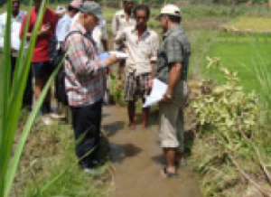
Detail survey and investigation (topography, geological socio-economic, agriculture, soil), planning and design and preparation of implementation plan of irrigation system (in block of 28 ha) and drainage system covering 3,000 ha command area of Siddaniya branch canal (off-taking at 30+050 of Main Canal) of Sikta Irrigation Project.

Main scope of work included:

  • Preparation of layout plan of the secondary and lower order canals to a level that enable water delivery to a block of 28 ha overlay the whole planning of such irrigation system on the topographical map.
  • Collection of information of existing irrigation schemes from secondary sources and from field.
  • Collection of socio-economic and agricultural data from secondary sources and from the field.
  • Collection of geological data from secondary sources and from the field.
  • Collection of hydro-meteorological data and assess irrigation water requirement for the Project Area.
  • Proposed suitable cropping patterns for the Project Area for with project condition.
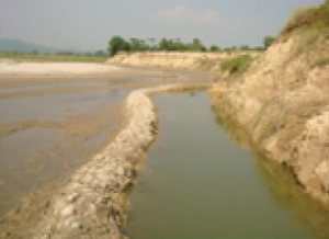
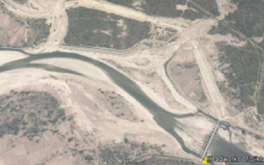
  • Preparation of Irrigation system plan of the Project Area considering the available water in Rapti River and Mahakali River and the water requirement for Left Command Area.
  • Detailed survey of canal networks for command area development works of Chandani-Dodhara canal command.
  • Optimize canal system plan to the tune of available water to be optimally diverted from Rapti River towards the command area in the right bank of Rapti River.
  • Detailed design of canal system including canal and drainage structures and command area development works.
  • Preparation of drainage development plan and design field, tertiary as well as secondary level drainage systems including associated structures, outfall to natural stream and protection works where found necessary.
  • Preparation of detailed design drawings and cost estimates.
  • Preparation of implementation plan of canal system.

Preparation of Subproject Preparation Report including IEE, Agricultural Development Plan and Livelihood Plan of 42 Irrigation Subprojects of Batch II; Community Managed Irrigated Agricultural Sector Project

pspr1 pspr2 pspr3

Client: Department of Irrigation
Funding Agency: Asian Development Bank
Period: July 2009 to December 2010
Consulting Association: GITEC – PRECAR- EAST – GEOCE JV
Approx. Value of Services: Total- NRs 19 million
Professional Staff Input: National (117) person months

Salient Details:

The Project has two components:(i) participatory irrigated agriculture development for farmer-managed irrigation systems (FMIS) comprising  improvement of agriculture productivity and sustainability of about 210 existing FMIS (covering 34,000 ha command area) suffering from low productivity and high poverty incidence, and thus enhance the livelihood of about 270,000 poor men and women including ethnic minorities and dalit living in the project area; and (ii) institutional strengthening and project management (ISPM) component to culminate in operation of mechanisms for improved service delivery to develop productive and sustainable FMIS through further improved irrigation policies, regulations, and plans; strengthened Department of Irrigation (DOI) (in terms of human resources and management capacity), Department of Agriculture (DOA), local governance institutions (LGIs), and WUAs; and enhanced institutional linkages to deliver services in coordination with NGOs and the private sector. The project covered 35 districts of Central and Eastern Regions. The project cost is US$ 22 M.

The scope of work included Feasibility study and preparation of Sub-project Preparation Report (SPPR) of following 42 irrigation subprojects of Batch II covering aggregate 5,106 ha command area. The scope of study also included IEE, Resettlement Plan, Agricultural Development Plan and Livelihood Enhancement Plan and preparation of Sub-project Preparation Report (SPPR). SPPR is a feasibility level study by using GPS tracking field survey. IEE Report and Resettlement Plan were carried out in accordance with Safeguard Policy Statement (SPS) of Asian Development Bank.

SN

Name of Sub-project

Location

C A in ha

SN

Name of Sub-project

Location

C A in ha

SN

Name of Sub-project

Location

C A in ha

1

Hattisar

Terahthum

76

15

Dobhan ISP

Okhaldunga

81

29

Diwalitole

Makwanpur

25

2

Hinguwa

Terahthum

83

16

Haribole

Okhaldunga

44

30

Ghoptebhir

Ramechhap

31

3

Bajrahi Guthi

Saptari

216

17

Kampek

Solukhumbu

61

31

Milti khola

Ramechap

39

4

Balan

Saptari

206

18

Charchare

Solukhumbu

64

32

Betegauda

Rasuwa

59

5

Mainawati

Siraha

304

19

Bagaiya Jamuni

Bara

217

33

Lamasoti Kundale

Rasuwa

32

6

Saraswoti

Khola

Siraha

201

20

Manikarnika-gahat

Bhaktapur

25

34

Lohiniya

Rautahat

200

7

Nagin Sarkari Kulo

Panchthar

101

21

Champawoti

Bhaktapur

25

35

Gaindatar

Rautahat

254

8

Labung Lewa

Panchthar

77

22

Niurenipani

Chitwan

69

36

Parwanipur Kalinjor

Sarlahi

395

9

Khahare Chuwabote

Taplejung

25

23

Riutamtagaghar

Chitwan

122

37

Banke Baba

Sarlahi

269

10

Unnat Katunje

Taplejung

39

24

Kamichaur

Dolakha

25

38

Tari

Sindhuli

32

11

Janta Kulo

Sankhuwas-abha

91

25

Srabesi

Dolakha

25

39

Bhaluwahi Barikulo

Sindhuli

270

12

Sahutar

Sankhuwasabha

31

26

Koirale Khola

Kathmandu

25

40

Thaljing Budepa

Sindhupalchok

48

13

Gaunfark

Khotang

109

27

Mahankal

Kathmandu

50

41

Ripini Dhotar

Sindhupalchok

32

14

Mewa Khola

Khotang

47

28

Motipur

Makwanpur

74

42

Vilwa Jamuni

Bara

876