
Detailed Survey, Design and Estimate of Dodhara-Chandani Area of Mahakali Irrigation Stage III Area
Client: Department of Irrigation
Funding Agency: Government of Nepal
Period: April 2012 to January 2014
Consulting Association: PRECAR- GEOCE JV
Approx. Value of Services: Total- NRs 3.77 million, GEOCE’s part- NRs 1.51 million
Professional Staff Input: National (64) person months
Salient Details:
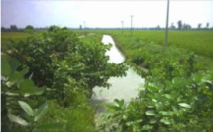
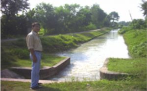
Detailed survey, design and cost estimate preparation of irrigation system covering 3,510 ha command area from Dodhara-Chadani Main Canal of Mahakali Irrigation Project Stage III
The Mahakali River in the east and the Jogbudha River in the west and south form the boundaries of the command area. Typically, the command area is north-south treading – about 16 km long and 2.4 km wide. The net command area is 3,510 ha excluding about 470 ha between Jogbudha and Indo-Nepal border outside the reach of Dodhara-Chandani Main Canal (DCMC). Long siphons are required; making the irrigation development for 450 ha areas uneconomical.
Main scope of work included:
- Preparation of layout plan of the secondary and lower order canals to a level that enable water delivery to a block of 28 ha overlay the whole planning of such irrigation system on the topographical map.
- Collection of information of existing irrigation schemes from secondary sources and from field.
- Collection of socio-economic and agricultural data from secondary sources and from the field.
- Collection of geological data from secondary sources and from the field.
- Collection of hydro-meteorological data and assess irrigation water requirement for the Project Area.
- Proposed suitable cropping patterns for the Project Area for with project condition.
- Preparation of Irrigation system plan of the Project Area considering the available water in Sharada Canal and Mahakali River and the water requirement for Command Area.
- Detailed survey of canal networks for command area development works of Chandani-Dodhara canal command.
- Optimize canal system plan to the tune of available water to be optimally diverted from Sharada Canal, India towards the command area in the left bank of Sharada Canal.
- Detailed design of canal system including canal and drainage structures and command area development works, which comprised design of main canal-35 km, branch canal-44 km, structures -1710 nos. including main, branch and tertiaries canals; main structures: C/D works-36 nos., field outlet-877 nos; shallow tube well development- 26 nos; drain escape- 10 nos; road pipe culvert-10 nos; double barrel VRB-18 nos; single barrel VRB for secondary canals- 45 nos; single barrel VRB for tertiary canals-107 nos; drop structures for DCMC-10 nos; drop structures for secondary canals- 36 nos; drop structures for tertiary canals-143 nos; drop cum double barrel VRB for DCMC- 9 nos; drop cum single barrel VRB for secondary canals – 12 nos; drop cum single barrel VRB for tertiary canals- 40 nos; aqueducts- 4 nos., HP siphon- 3 nos; head regulators and cross regulators -11 nos., gate keeper house 1 no, WUA building 1 no, O&M building 1 no. and Irish bridge- 2 nos.
- Design of Jogbudha river training work, 36.4 km
- Preparation of detailed design drawings and cost estimates.
- Preparation of implementation plan of canal system.
Client: Department of Irrigation
Funding Agency: Government of Nepal
Period: April 2012 to January 2014
Consulting Association: PRECAR- GEOCE JV
Approx. Value of Services: Total- NRs 3.77 million, GEOCE’s part- NRs 1.51 million
Professional Staff Input: National (64) person months
Salient Details:
Detailed survey, design and cost estimate preparation of irrigation system covering 3,510 ha command area from Dodhara-Chadani Main Canal of Mahakali Irrigation Project Stage III
The Mahakali River in the east and the Jogbudha River in the west and south form the boundaries of the command area. Typically, the command area is north-south treading – about 16 km long and 2.4 km wide. The net command area is 3,510 ha excluding about 470 ha between Jogbudha and Indo-Nepal border outside the reach of Dodhara-Chandani Main Canal (DCMC). Long siphons are required; making the irrigation development for 450 ha areas uneconomical.
Main scope of work included:
- Preparation of layout plan of the secondary and lower order canals to a level that enable water delivery to a block of 28 ha overlay the whole planning of such irrigation system on the topographical map.
- Collection of information of existing irrigation schemes from secondary sources and from field.
- Collection of socio-economic and agricultural data from secondary sources and from the field.
- Collection of geological data from secondary sources and from the field.
- Collection of hydro-meteorological data and assess irrigation water requirement for the Project Area.
- Proposed suitable cropping patterns for the Project Area for with project condition.
- Preparation of Irrigation system plan of the Project Area considering the available water in Sharada Canal and Mahakali River and the water requirement for Command Area.
- Detailed survey of canal networks for command area development works of Chandani-Dodhara canal command.
- Optimize canal system plan to the tune of available water to be optimally diverted from Sharada Canal, India towards the command area in the left bank of Sharada Canal.
- Detailed design of canal system including canal and drainage structures and command area development works, which comprised design of main canal-35 km, branch canal-44 km, structures -1710 nos. including main, branch and tertiaries canals; main structures: C/D works-36 nos., field outlet-877 nos; shallow tube well development- 26 nos; drain escape- 10 nos; road pipe culvert-10 nos; double barrel VRB-18 nos; single barrel VRB for secondary canals- 45 nos; single barrel VRB for tertiary canals-107 nos; drop structures for DCMC-10 nos; drop structures for secondary canals- 36 nos; drop structures for tertiary canals-143 nos; drop cum double barrel VRB for DCMC- 9 nos; drop cum single barrel VRB for secondary canals – 12 nos; drop cum single barrel VRB for tertiary canals- 40 nos; aqueducts- 4 nos., HP siphon- 3 nos; head regulators and cross regulators -11 nos., gate keeper house 1 no, WUA building 1 no, O&M building 1 no. and Irish bridge- 2 nos.
- Design of Jogbudha river training work, 36.4 km
- Preparation of detailed design drawings and cost estimates.
- Preparation of implementation plan of canal system.